
I'm thinking that since there was no snow cover we could be looking at much lower lake levels. I've been looking at staying at cottages on the inner bay channels and am wondering how high I'll have to climb up to get in/out of the boat?
You are using an out of date browser. It may not display this or other websites correctly.
You should upgrade or use an alternative browser.
You should upgrade or use an alternative browser.
So what are the estimated lake levels going to be this year?
- Thread starter Outdorman
- Start date
walleyeman
Well-Known Member
That is a tough call Outdorman! I am guessing on waiting to see how much precip we get in early April. This my friend could tell you how high or low Lake Levels could be! We do have quite a bit of snow-pack on land. I guess it is wait and see! Cheers- Walleyeman.
spearfisher
Well-Known Member
Lake levels are trending down and will likely continue to go down from the historic highs of 2019. Go to the ijc website ijc.org and theybhave water level predictions and show past history. The lack of ice this yr will likely increase evaporation and drop levels faster.
Old Cut LongPointer
Well-Known Member
I'm with Spearfisher on that question. Thankfully the water level dropped at the end of last year and with no ice cover the lake could breathe (evaporate water) . Not having ice cover makes a huge difference ! The level of course will go up as per seasonal norm and peak in August so unless we have a lot of rain or there is a large amount of snow further north that has to melt we should have a normal year. The wild card in predicting this is Mother Nature and she's been having hissy fits lately.
hvyhaul
Well-Known Member
My Burwell dock has been a floater the last few years, so in and out of the boat hasn't been an issue.
Getting in and out of Burwell might be if the water level drops too much.
Been a number of boaters already get a rude awakening out by the channel markers with 2022's level.

Getting in and out of Burwell might be if the water level drops too much.
Been a number of boaters already get a rude awakening out by the channel markers with 2022's level.
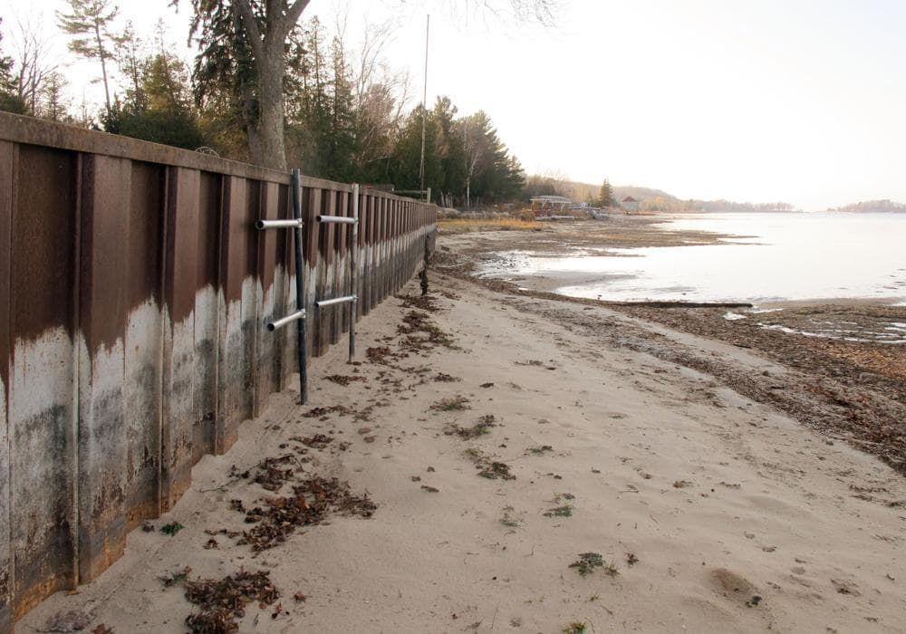
As long as the boat launch area doesn't look like this we'll be good to go.
Weather network folks are talking about this year being the end of a 3-year La Nina and they are predicting a dry year ahead for our region.
Ha ha! since when did the Weather Network folks ever get it right. Batting only 50% but still keep their jobs. LOL!Weather network folks are talking about this year being the end of a 3-year La Nina and they are predicting a dry year ahead for our region.
FlyingViking
Well-Known Member
Lake Ontario and basin water levels are controlled by “Plan 2014” that was signed by Obama and Trudeau in 2017.
We have personal experience with this “plan” as my girlfriends cottage property was deemed not habitable after flooding on the seaway on St.Lawrence. Insurance did not cover a dime and the property is now “watershed”
Prior to this plan that controls the basin water levels. Insurance would have picked up this tab. “Plan 2014” has actually written into it that if rising water levels damage your property “lakeside” or in the watershed, insurance can be deemed “not included”.
We know of 7 other property owners that have been effected by this government controlled raising and lowering of water levels.
Not many people are aware of “plan 2014” and are told it’s “climate change”. It’s worth a bit of research before your insurance walks away from your property…
Old Cut LongPointer
Well-Known Member
Plan 2014 only pertains to Lake Ontario and St. Lawrence River and doesn't affect the upper lakes.
Most weather networks use almost the same computer modeling from information obtained from agencies like Environment Canada, NOAA, etc., etc. and can actually be 70-80 percent right for a 7 day forecast, so considering how new that tool is predictions can only get better but like I said Mother Nature can be a fickle bitch.
We should have a draw or pool to see who picks the highest and/or most accurate lake level for Erie ? Use the Army Corps of Engineers as the control factor and your guess must be logged in by the end of June and results at the end of August ? Ten bucks a pick and all the money goes to a charity ? Something to do with taking inner city kids fishing or .... ? Maybe get the LPBAA or LPAF&GC to facilitate and/or local biz to donate ?
FlyingViking
Well-Known Member
That’s actually not right. Here is the map that is impacted by Plan 2014

done working
Well-Known Member
Pretty sure that this map shows the lake O watershed, where the water flows directly into lake Ontario. It is my understanding that other than the little bit of water that is diverted to the hydro station headponds on the Canadian and US sides of the Niagara river, Lake Erie's water level is for the most part uncontrolledly.
FlyingViking
Well-Known Member
Well, except when the government closed niagara river relief and raised Erie by a few feet.
Not sure if many when the Niagara river and falls was shut off? Lake Erie is fully controlled. Courtesy of the flood plains such as the Grand
Not sure if many when the Niagara river and falls was shut off? Lake Erie is fully controlled. Courtesy of the flood plains such as the Grand
In 1848? You are older than Stomp's strawhat!!!
spearfisher
Well-Known Member
Done working is rt. There is little or no control over erie. If the water isnt siphoned off for hydro by opg or nypa it goes over the falls. There is a weir that controls some water level on upper niagara for hydro intakes but its a partial weir to elevate grass island pool. No impact on l erie.
spearfisher
Well-Known Member
Plan 2014 is still a work in progress. There is lots of variation in st Lawrence water levels, always has been since moses saunders was built. Lots of factors at play on the st Lawrence, shipping, water levels in mtl, ott r water levels, higher spring ecological levels for fish wildlife in marshes.
FlyingViking
Well-Known Member
Aaactually… the variability and variations are controlled by the USA and Canada GL’s water level agreementsPlan 2014 is still a work in progress. There is lots of variation in st Lawrence water levels, always has been since moses saunders was built. Lots of factors at play on the st Lawrence, shipping, water levels in mtl, ott r water levels, higher spring ecological levels for fish wildlife in marshes.
Old Cut LongPointer
Well-Known Member
I could see an ice dam at the mouth of Niagara River backing up water in Lake Erie but then again a seiche could push more water down the river thereby lowering the lake level.
Water levels are in fact controlled on Erie. Not so much on the discharge end but on the inflows from Lake Superior. Many changes over the years have changed the natural water flow rate from the north, which has raised all the great Lakes and rivers downstream.