
would have been one hell of a ride... did you know the driver ?
You are using an out of date browser. It may not display this or other websites correctly.
You should upgrade or use an alternative browser.
You should upgrade or use an alternative browser.
When did Brian Campbell buy N.E.M. ?
- Thread starter Woodsman
- Start date
I just heard on CNN that Brian Campbell also purchased Bee-Line Trailer Park??? 

packrat
Well-Known Member
Is that all-- I heard he bought out the other bait dealers plus the coffee shops and has control of access to the public washroomsI just heard on CNN that Brian Campbell also purchased Bee-Line Trailer Park???
View attachment 7836
This bridge is it sold by the foot or the yard, and is there HST on the sale? Did you also purchase the truck ? You have bought up much of Bruce lately !!!!!!
Is that all-- I heard he bought out the other bait dealers plus the coffee shops and has control of access to the public washrooms
Now that is total control!
well with all joking aside,there is one more major problem here just waiting to happen,that ccca and tws,county is more then aware of and just play the blame game and its going to happen,and when it does port bruce will be a new island nation cut off totally i look at it every day,and so have they and do studies and no action or preventive plan when lets go ,no one can say they didn t no,
Last edited:
WHat is the subject of that paragraph? I do not understand what the major problem is that you are referring to.well with all joking aside,there is one more major problem here just waiting to happen,that ccca and tws,county is more then aware of and just play the blame game and its going to happen,and when it does port bruce will be a new island nation cut off totally i look at it every day,and so have they and do studies and no action or preventive plan when lets go ,no one can say they didn t no,
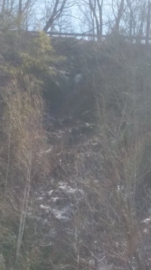
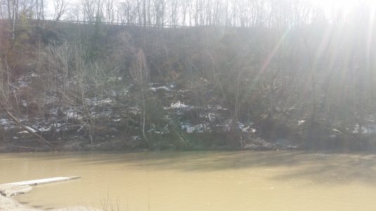
as of now there is only one way to reach the south side of port bruce on dexter line,and up to 3 or 4 years ago the plan was just to close it all together.as you enter or leave town there is ersion under that roadway that you could fit that dump truck in and the whole slop is sliding into the river,the toe of the slope gave out 4 years ago causing a jam in the river.in mid summer.when this happened i call tws and ccca declaring an emergancey,after hours of no response i called in excavator and dump trucks (they dropped everything load up and here in 30 minutes) to clear it and get control,at a my cost every boat and dock would have been taken out to the mouth of river.When we were done got shit for it and told we should have pushed it out and let it be the next guys problem . A year later the slope dropped under the hy way anoff to shake the hole area for miles ,this area was all ready noted to be unsafe by ccca and county engineers 6 years ago,but now its way worse today,they paid millions to move hyway concerning it would fall in the lake100 meters away,but reality is even as of today its going to collapse 100 ft straight down into the river. if the hydro polls now sit on a 30 degree angle does that not indicate a problem? the catch basins are on river side leaking under road soaking a 75 degree slope,stripped of all ground cover.
every official no's this,and now direct all traffic over it,heaven forbid it does now,and this just kinda thing just happened outside of port burwell and that very same dump truck drove over that hole 45 seconds before it got to the bridge on its way to fix the hyway in burwell
look what just happend in California mud slides
no pro activeness just wait and see approach
Thank you for explaining that.as of now there is only one way to reach the south side of port bruce on dexter line,and up to 3 or 4 years ago the plan was just to close it all together.as you enter or leave town there is ersion under that roadway that you could fit that dump truck in and the whole slop is sliding into the river,the toe of the slope gave out 4 years ago causing a jam in the river.in mid summer.when this happened i call tws and ccca declaring an emergancey,after hours of no response i called in excavator and dump trucks (they dropped everything load up and here in 30 minutes) to clear it and get control,at a my cost every boat and dock would have been taken out to the mouth of river.When we were done got shit for it and told we should have pushed it out and let it be the next guys problem . A year later the slope dropped under the hy way anoff to shake the hole area for miles ,this area was all ready noted to be unsafe by ccca and county engineers 6 years ago,but now its way worse today,they paid millions to move hyway concerning it would fall in the lake100 meters away,but reality is even as of today its going to collapse 100 ft straight down into the river. if the hydro polls now sit on a 30 degree angle does that not indicate a problem? the catch basins are on river side leaking under road soaking a 75 degree slope,stripped of all ground cover.
every official no's this,and now direct all traffic over it,heaven forbid it does now,and this just kinda thing just happened outside of port burwell and that very same dump truck drove over that hole 45 seconds before it got to the bridge on its way to fix the hyway in burwell
look what just happend in California mud slides
no pro activeness just wait and see approach
Hey @rushcreek... maybe post some pictures of what you are seeing down there? I'm sure many here would be interested.
I'm not sure, but I think this may be what he is talking about, (view in satellite mode) : https://www.google.ca/maps/place/De...038c07c50e12d5!8m2!3d42.6733074!4d-81.1093531Hey @rushcreek... maybe post some pictures of what you are seeing down there? I'm sure many here would be interested.
i only have cell phone camera but will do,but in order to get perspective really need something in back ground,as of now there will be no large rigs using that section of road,but i think the shcool buses will so i will try that.but can not for a few days i will be away for a next couple days.
(need a drown)
the google map must be a few years old and trees cover it up..I can also tell because the two new storm drain 10's of acre ponds built on and in a flood zone on the the top end of a village pron to flooding that just needed another place to store million tons water and make ice and flush it threw town.
These ponds were done with the intentions for ducks by the ccca? but co inside with moved hyway and massive new storm drains and done with no land change permits ,no engineering,and no public consultation of ajesent land owners...???? with no mention of in plans for new road
all that new surface ice has to go some were?
Hey @rushcreek... maybe post some pictures of what you are seeing down there? I'm sure many here would be interested.
Hey @rushcreek... maybe post some pictures of what you are seeing down there? I'm sure many here would be interested.
best i could do for now ,not great pictures
Attachments
Last edited: