Off Topic Inner Bay restrictions

Outdorman

Well-Known Member
R.O.C. (Radio Operator's Certificate)
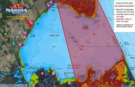
This is my first year fishing out of Marina Shores and I checked the regs and no fishing allowed till later in May for the inner bay. I do't have a map and all the ministry provides is GPS co-ordinates and am wondering what the common sense boundary is for the inner bay? Any idea how far out from Marina Shores you have to go to fish? Also it would be nice to hear about where the one line per person line is.

thanks
 
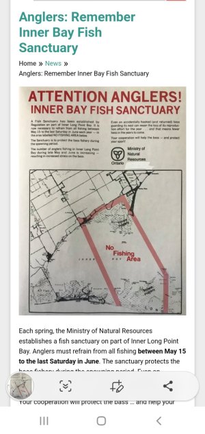
Only one line is permitted within the Inner bay, West of a line from Pottahawk Point to Tutkey Point. There are signs posted every couple hundred meters in the water once the closure beginning May 15th till the 4th Saturdayin June. The sanctuary is from this same line West to a line just east of Booths Harbour to the East of Old Cut.
 

Attachments

  • Screenshot_20230506-133338_Samsung Internet.jpg
    Screenshot_20230506-133338_Samsung Internet.jpg
    170.1 KB · Views: 53
Last edited:
thanks Chico for the picture. was that something you found on line or in the regs book? I would be interested in my own copy as it is exactly what I am looking for. Looks like if I'm in the inner inner bay I could still troll a bit for Pike.
 
The inner half line is difficult to know for sure. Basically from the St Williams lighthouse over to the LPB provincial park marina. Then TP over to pottahawk is the outer line
 
It's closed to any fishing from may 15th until the fourth Saturday in June, no exceptions
 
well looks like if I'm in close to the bay I can still fish, guess the best thing is to buy a map and draw lines based on the co-ordinates, thanks all for the info
 
well looks like if I'm in close to the bay I can still fish, guess the best thing is to buy a map and draw lines based on the co-ordinates, thanks all for the info
Just a suggestion for any one who doesn't know, start out from the provincial park and head directly to the St Williams lighthouse making marks on your fish finder repeatedly along the way. Then change the symbols to something recognizable to know where the line is. The TP line to pottahawk is easier to visualize while out there
 
Stomp has that map posted in the "Maps" at the top header of this site. Unfortunately the government doesn't like to supply detailed maps but the Western Line runs from Little Rice Point to the St. Williams Lighthouse and the Eastern Line runs between Turkey Point and Pottahawk Point and woe to the fisherman that gets caught with a line in the water anywhere in between those boundary lines. They may have used a fat marker to draw the lines on the map but the ticket they hand you is done with a Fine Point pen. Needless to say all Bass are out of season until the fourth Saturday of June but darn near everything else is OK. As a disclaimer please check the newest Fishing Reg's Summary.

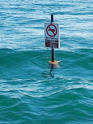
The MNR use to mark the boundary lines with buoys that had the No Fishing/Fish Sanctuary symbol on them , not sure if they do that anymore ?
 
I believe the only year the bay hasn't been marked was because of COVID in May of 2020. It has been clearly marked every year before and after.

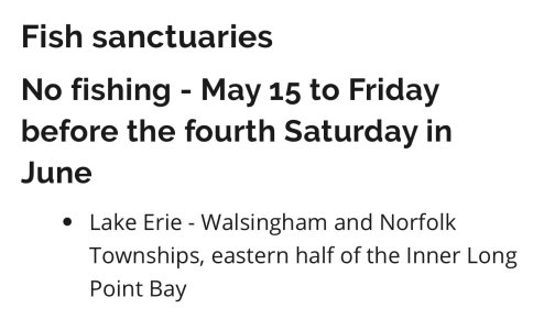
Also take note that the sign says May 15 until the last Saturday in June, but it's actually the fourth Saturday in June. Which can be confusing when there happens to be five Saturdays on certain years.
 

Attachments

  • 20210515_163230.jpg
    20210515_163230.jpg
    344.7 KB · Views: 23
I believe the only year the bay hasn't been marked was because of COVID in May of 2020. It has been clearly marked every year before and after.

Also take note that the sign says May 15 until the last Saturday in June, but it's actually the fourth Saturday in June. Which can be confusing when there happens to be five Saturdays on certain years.
Thanks for posting that photo @Extra Virgin 👍 I remember seeing those signs before COVID. 👍🙂
 
reading from 2023 regs....... and there is no definition of "Eastern Half of the Inner Long Point Bay. To me eastern half means all of the east side of inner bay and does not indicate that there is a sliver that is sanctuary and that in the far most eastern area is available to fish. I would be very careful as there is no map or GPS co-ordinates in the regs this year. Also the regs say that all of the inner bay are one rod only.

all this is very confusing and I wish they would put in a map or GPS.

I got busted years ago with two rods in St Claire near Peche Island and the MNR guy told me it was "a local rule" not posted anywhere and I was clearly in the lake according to every Coast Guard map I could find. Had to drive to Windsor to fight it and I couldn't get time off work.
 
The full definition of the sanctuary area from the Ontario Fishery Regulations (not the regs summary) is as follows:

The waters of that part of Lake Erie in the townships of Delhi and Norfolk, in the Regional Municipality of Haldimand-Norfolk, being composed of all the waters of Inner Bay of Long Point Bay, including all waters joining said Inner Bay lying within the following limits: commencing at the intersection of the water’s edge of Inner Bay of Long Point Bay with the westerly limit of Lot 1, Concession B, as shown on the plan of the Township of Charlotteville; thence northerly along that westerly limit to the intersection with the easterly limit of the right-of-way of Haldimand-Norfolk Region Road Number 16; thence northerly along that easterly limit to the intersection with the southerly limit of the right-of-way of the travelled road known locally as Front Road; thence easterly along that southerly limit across Lots 1 to 10 inclusive, Concession B, as shown on the plan of the Township of Charlotteville, to the intersection with the northwesterly production of a line joining a control survey monument, indexed with the Ontario Ministry of Natural Resources and Forestry as station 008750128, located on the northerly extremity of Pottahawk Point, 42°36′35.76073″N., 80°17′10.00336″W. and a control survey monument, indexed with the Ontario Ministry of Natural Resources and Forestry as station 008750127, located on the lands of the Turkey Point Marina, 42°39′57.40627″N., 80°19′52.25129″W.; thence southeasterly along the northwesterly production and the line to the said control survey monument on Pottahawk Point; thence south astronomically to the water’s edge along the southerly shore of Long Point; thence westerly along that water’s edge to the intersection with a line drawn on a course of south 26°00′ east from the place of beginning; thence north 26°00′ west along that line to the place of beginning.


Simple :-P

The definition hasn’t changed and the old maps above are still correct. The “one rod” rule hasn’t changed. The boundary of the inner bay, as pertains to the one rod rule is as follows:

(b) Inner Bay of Long Point Bay, including the waters west of a line drawn from Turkey Point Marina at 42º39′57.4″ N, 80º19′52.5″ W to Pottawhawk Point at 42º35′35″ N, 80°17′10.0″ W;
 
Back
Top
AdBlock Detected

We get it, advertisements are annoying!

Advertising is what keeps Channel 6-8 on the air. To this end, please take a moment to disable your AdBlocker. If you would prefer an ad-free experience, but would still like to help support site operations, please consider making a donation.

I've Disabled AdBlock    No Thanks