Fishing Report 31. Nanticoke

SIX-GRAND

Well-Known Member
R.O.C. (Radio Operator's Certificate)
Hit the launch at 630 Off to the walleye grounds.
Put 4 Lines in at 7pm in 63fow ESE heading . 2five colr Lead on inline boards 2 five color strait back. Had to many hits with no hook up last outing so i decided to try something different.
2 flicker shad(1deep&1shallow lip) on 1side and to spoons on other.
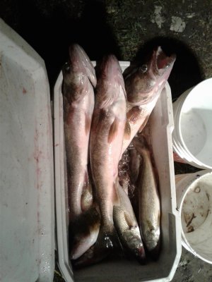
We did 1 pass, just under 20mins picked up 6. 1 biggin that took it to the gills. Spoon(nk in anti-freez) Cought 1 of 6. Swapped out the spoons for 2 more flicker shad. Fished till 930. 28 walleye 1whitebass made it to the boat. Lost 2. Best flicker was jointed in anti-freez and second was the shallow in fancy smelt.
The Flicker shad was marvelous! 20190731_225346.jpg20190731_192039.jpgEvery hit looked like it was a 7+pounder on the line.. Only real issue was we Cought 3 biggins(5-8lbs) that all out crushed it! Took the baits deep every time. Would have rather released fish of that caliber but they was toast.
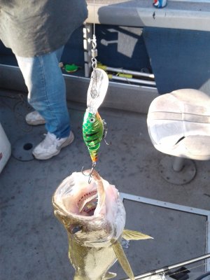
Even a couple small guys had just the "lip" sticking out of there mouth.
Never did try any RRF's or more then the 2 spoons I started with.
Once again it was a Marvalous day to be on the erie waters. Many anglers out for a wendsday evening.
 
Antifreeze has been a hot color for you... That's some good action... I release anything 8lb+ as well as long as there healthy... Your reports make it hard to focus on work... :)
 
We fished from 4:30 - 7:30 east of nanticoke shoal and got our 3 man limit of nice sized fish, biggest ones were 27". 3, 5, 6, & 7 colour leads off the big boards but the deeper lines did better today. Redfins of all colours did well but the Greasy Chicken spoon was on fire again.

There is a suspended gill net running N-S about the middle of the 'no anchorage' box east of the shoal so be aware if you're out today. You can cross between the black flags which are gates but not where the white jugs are.
 
GMech thanks for the heads-up about the nets.

How far east are they from the shoal? What exactly is the no anchorage? Is the area marked? Thanks
 
GMech thanks for the heads-up about the nets.

How far east are they from the shoal? What exactly is the no anchorage? Is the area marked? Thanks

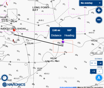
The 'No Anchor' box should show up on your nav charts but here is a snip from the handy interactive map (tab at the top of the forum home page). It is about 2.8 miles east of the shoal. The net will likely get moved today but that's where is was yesterday and it was a loooooong one with multiple gates running N-S from the middle of the box towards shore.


1564659803248.png
 
what is a no anchorage box..what does this mean..

It is just an area indicated by the red rectangle on the map above. It shows on the navigation charts and on your chart plotter (assuming that overlay is turned on). It is a warning to freighters not to anchor in that area due to some sort of obstruction on the bottom. It just happens to be in area lots of people fish and has kind of become a landmark although there are no physical buoys or anything out there. It's kind of a similar idea to "the elbow", it's just a an area that has become known by that name there isn't really anything there (except me and a net in this case!).
 
Last edited:
There are at least 3 more sets of net going east passed the spot G.Mech Mentioned. All running north-south ending in about 70fow.

Good to hear you bagged your limit G.Mech. I talked to a couple anglers comming off while I was launching. They said they only managed 3 walleye for ther efforts running riggers and dipsy and the friend in another boat only 1lake trout fishing 60fow running spoons. I thought it was going to be a tough evening to fish after hearing that.
 
Antifreeze has been a hot color for you... That's some good action... I release anything 8lb+ as well as long as there healthy... Your reports make it hard to focus on work... :)
Yeah that anti-freez color has been great this year. Whether it be a spoon or minnow bait she seems to be a good color for the way I'm presenting my gear.

I had recently added few "Bayrats" to my line up but never did get to washing them..they were next to go for a swim if the flicker shads didn't produce. They look well made. Small but Heavy duty split rings. Quality sharp hooks, looks like I dont have to change anyting!
I'll be sure to run them on a couple rods next outing.
Only crankbait company who's stock hooks will hold kings... ;)
 
The 'No Anchor' box should show up on your nav charts but here is a snip from the handy interactive map (tab at the top of the forum home page). It is about 2.8 miles east of the shoal. The net will likely get moved today but that's where is was yesterday and it was a loooooong one with multiple gates running N-S from the middle of the box towards shore.


View attachment 16569
Thanks for this?, I was pretty much all alone in this area last night. But the fish were there
 
Was there last night and i didn't see any nets. Not to say they are not there just on my track south of the shoal.
 
The 'No Anchor' box should show up on your nav charts but here is a snip from the handy interactive map (tab at the top of the forum home page). It is about 2.8 miles east of the shoal. The net will likely get moved today but that's where is was yesterday and it was a loooooong one with multiple gates running N-S from the middle of the box towards shore.


View attachment 16569
That's the old dumping ground or spoil area from the construction of Hydro and Stelco in the 70's. Same as the one on the North side of the shoal. Dump scows would drop their contents of mud and rock out there. Both good spots to fish. On some charts they're called "Spoils Area" and represented with horizontal looking dollar sign.
 
That's the old dumping ground or spoil area from the construction of Hydro and Stelco in the 70's. Same as the one on the North side of the shoal. Dump scows would drop their contents of mud and rock out there. Both good spots to fish. On some charts they're called "Spoils Area" and represented with horizontal looking dollar sign.

Thanks for clarifying that @SOUTHWIND . On my navionics chart it's marked as 'no anchorage' and I'm pretty sure that's what it said on the old paper charts as well but it sounds logical that that's what it could be. I will put my downscan/sidescan on next time and see if I see Jimmy Hoffa or anything else of interest. I will dig out the old 80's paper charts and see how they're marked on there just for fun too.
 
Back
Top